Nepal Quake Mystery Solved: Powerful Landslide Triggered Deadly Flash Floods
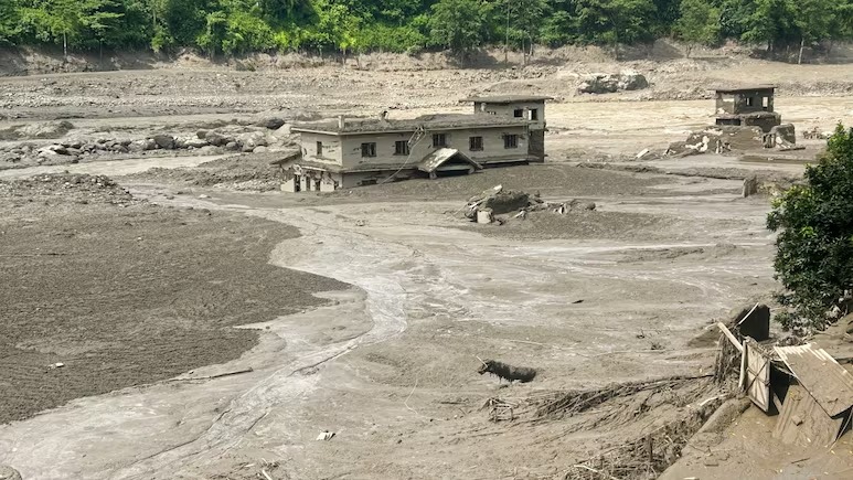
The tremors reported in Nepal on August 26 have now been linked to a powerful landslide rather than a conventional earthquake. The USGS clarification came after an initial seismic reading identified what appeared to be a 4.4-magnitude earthquake near the Nepal-China border.
The development has changed the understanding of one of the deadliest natural disasters to hit the Himalayan region this week. What people initially experienced as earthquake-like shaking was connected to a huge mass of rock, ice and debris moving down a mountain slope and entering a river system.
That landslide then produced a sudden and destructive surge of water through downstream areas. Villages, roads, bridges and important infrastructure were overwhelmed within a very short period, leaving rescue teams facing an extremely difficult situation.
Why The Quake Report Changed
Early reports created understandable confusion because seismic monitoring equipment detected strong ground movement around 8:37 am Nepal time on Wednesday. The United States Geological Survey initially classified the signal as a 4.4-magnitude earthquake close to the Nepal-China border.
Later analysis pointed toward a different explanation. Instead of movement along a tectonic fault creating the shaking, a massive landslide was responsible for producing the seismic signal detected by monitoring instruments.
This distinction matters because an earthquake and a landslide can produce very different disaster chains. An earthquake can directly damage buildings and trigger landslides, while a landslide entering a river can suddenly create a powerful flood wave downstream.
In this case, the second chain appears to have been especially important. The collapse sent a huge quantity of material into the Lhende Khola river, which is connected to the Bhote Koshi river system flowing from Tibet into Nepal.
A Landslide With Earthquake-Like Force
Calling the event a landslide does not mean the physical impact was minor. Quite the opposite happened in the Himalayan mountains, where enormous slopes can hold huge amounts of rock, ice, snow and loose material.
When such material suddenly collapses, the movement can generate measurable seismic waves. Instruments may therefore detect the event in a way that resembles an earthquake, particularly when information is being processed rapidly during an unfolding disaster.
Reports indicate that the landslide was later associated with energy equivalent to a magnitude 5.2 earthquake. That figure helps explain why residents and monitoring systems could detect significant shaking even though the main event was not a tectonic earthquake.
The important point is that magnitude-style measurements can describe the energy released by different physical events, while the underlying causes remain completely different.
How The Deadly Flood Developed
The most devastating part of the disaster was not simply the ground movement. It was the sudden interaction between the mountain collapse and the river.
When the massive landslide entered the waterway, it displaced enormous quantities of water and debris. That created a destructive surge that moved downstream with little warning for communities located along the river system.
The resulting flash floods swept through settlements and damaged infrastructure across Nepal’s Rasuwa district. Reuters reported that homes, roads and hydropower facilities were among the structures affected by the disaster.
The destruction also extended toward the Tibet side of the border, showing how quickly high-mountain disasters can cross administrative boundaries.
For people living beside rivers, there was little time to understand what was happening. The sudden arrival of a large flood wave can turn an apparently normal morning into an emergency within minutes.
Death Toll And Missing People
The disaster has caused a major humanitarian crisis, with authorities reporting a rapidly changing number of deaths and missing people as rescue operations continue.
Nepal authorities had recovered at least 157 bodies, while hundreds of people remained unaccounted for. The missing included both local residents and foreign visitors who were travelling through the region.
The situation was particularly worrying because the affected region attracts trekkers, tourists and pilgrims. Some travellers were reportedly near the border areas when the flood struck, making communication and evacuation even harder.
China also reported deaths and missing people on its side of the border. The Associated Press reported three confirmed deaths in Tibet along with hundreds of people missing there.
Search teams now face unstable terrain, damaged roads and blocked routes. Those conditions can slow rescue work considerably, especially when helicopters and emergency vehicles cannot reach isolated locations easily.
Why Himalayan Slopes Are Vulnerable
Nepal’s geography makes this kind of disaster especially dangerous. The Himalayan region contains extremely steep slopes, deep valleys and rivers that move through narrow channels.
A large slope failure can therefore have consequences far beyond the original collapse point. Once debris reaches a river, it can block the channel, suddenly release stored water or create a fast-moving mixture of mud, rocks and water.
The region is also experiencing changes in its mountain environment. Reuters reported that experts were examining whether glacier collapse and recent high temperatures contributed to the disaster. Satellite imagery reportedly showed a substantial section of a glacier breaking away at an altitude of around 5,200 metres.
Scientists are still examining exactly what initiated the collapse. That means it would be premature to describe one single factor as the confirmed cause.
Earthquake Or Landslide: Why It Matters
The difference between an earthquake and landslide is more than a technical detail for scientists. It affects how authorities interpret warning signals and how people understand future risks.
Earthquake monitoring systems are designed to identify seismic waves and rapidly estimate where an earthquake may have occurred. A large landslide can also produce seismic signals, creating difficult situations when monitoring information is being processed during an emergency.
USGS already maintains systems for studying ground failure and landslide hazards associated with earthquakes. Its ground-failure products provide near-real-time information about earthquake-triggered landslides and related hazards.
The Nepal incident highlights why seismic readings sometimes need additional geological and satellite information before the exact cause can be established.
For ordinary residents, however, the distinction can be confusing. If the ground shakes, people naturally assume an earthquake has occurred, especially in a country with Nepal’s long history of major earthquakes.
Nepal Has Long Faced Earthquake Risks
Nepal remains one of the world’s best-known earthquake-prone regions because it sits within the complex Himalayan collision zone.
The country experienced the devastating magnitude 7.8 Gorkha earthquake in 2015, which caused enormous destruction and triggered thousands of landslides across the mountains. USGS research later identified at least 25,000 landslides associated with that earthquake and its aftershock sequence.
That history explains why any report of significant shaking in Nepal immediately attracts attention.
However, the latest disaster demonstrates another problem. Even when an earthquake is not responsible, mountain communities can experience extremely violent ground movement and flooding from slope failures.
This means disaster preparedness cannot focus exclusively on earthquakes. Landslides, glacier collapses, flash floods and river blockages also require serious monitoring and emergency planning.
Rescue Operations Face Major Challenges
Rescue teams working in mountainous terrain rarely have easy conditions, and this disaster has created several additional problems.
Floodwater has damaged roads and bridges, while mud and debris have covered sections of transport routes. Reuters reported that infrastructure including bridges and roads was badly affected in the disaster zone.
That creates a difficult cycle. Emergency teams need roads to reach isolated communities, but the same disaster has damaged or removed those roads.
Helicopters can provide an alternative, although weather, visibility, landing locations and mountain terrain can restrict operations. Rescue workers also have to consider the possibility of additional landslides and unstable slopes.
The priority remains locating missing people, helping survivors and restoring access to affected communities. Authorities are also warning people to remain cautious around rivers because additional blockages or sudden releases could create further flooding.
What This Means For Future Monitoring
The Nepal disaster could provide important lessons for mountain regions around the world.
A seismic signal should not always be interpreted as proof that a tectonic earthquake has occurred. Combining seismic data with satellite imagery, river monitoring, glacier observations and local reports can provide a much clearer picture of what is happening on the ground.
This becomes especially important in remote Himalayan valleys where people may have very little warning before a major landslide reaches a river.
Early-warning systems can potentially save lives when they detect sudden changes in river levels or mountain slopes. But technology alone cannot solve every problem. Communities also need evacuation routes, emergency communication systems and regular disaster-preparedness exercises.
The incident therefore raises a broader question about how governments monitor rapidly changing mountain environments, particularly as climate-related changes alter snow, ice and water conditions.
The Bigger Warning From Nepal
The correction from earthquake to landslide does not make the disaster any less serious. Instead, it reveals how complicated natural hazards can become when several mountain processes interact within minutes.
The initial seismic reading was understandable given the strength of the ground signal, but further analysis changed the explanation. The devastating flooding was linked to a powerful landslide involving rock and ice, with the debris entering a river and generating a destructive downstream surge.
For Nepal, the immediate concern remains rescue and recovery. For scientists and disaster agencies, the event offers another reminder that Himalayan hazards cannot be placed neatly into one category.
The region needs stronger monitoring for earthquakes, landslides, glaciers and rivers at the same time. Better coordination between these systems could provide earlier warnings when another mountain collapse begins.
Conclusion
The Nepal disaster shows why natural hazards can be difficult to identify during their first moments. What initially appeared to be a 4.4-magnitude earthquake was later clarified by USGS as shaking associated with a powerful landslide, while the landslide itself helped trigger catastrophic flash flooding. The continuing rescue operation highlights the vulnerability of Himalayan communities, roads and river settlements to sudden mountain hazards. Understanding these events correctly can improve future warning systems and emergency planning. Readers should continue following verified updates from Nepalese authorities and established scientific monitoring agencies for accurate information as rescue operations continue.
Read More :-